A community interest company (CIC) in Northumberland has leased a section of disused railway to make it an active travel path after the 19th century bridges on the route were prevented from being infilled.
Borderline Greenway CIC has signed a 25-year lease with landowner Northumberland Estates for a 2.9km route that used to form part of the Alnwick to Cornhill line. This line opened in 1887 but it was a financial failure and the tracks were removed in 1953 when it closed.
The route has become an unofficial but popular walking route for locals in the area. Now the lease has been signed, Borderline Greenway is hoping to have it ready for pedestrians and wheelchair users in the summer and for cyclists and horse riders as soon as possible.
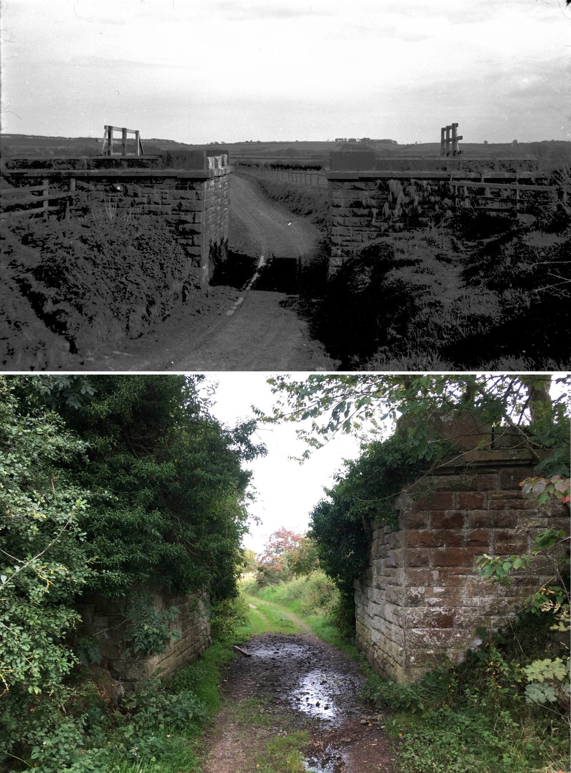
The route is especially beloved for the historic rail bridges along it, some of which are part of the Historical Railways Estate that is looked after by National Highways. However, the roads body was previously working towards infilling these bridges as it has done controversially in Cumbria and Norfolk.
Its contractor Jacobs wrote to Northumberland County Council in September 2020 saying that Alnwick Road bridge, a single span brick arch constructed circa 1887, had a capacity of 7.5t and “represents an ongoing and increasing risk to public safety”. It proposed to “undertake support works [...] via structural infill”.
When the news was reported in the local media, interested individuals in the area sprung to the bridges’ defence. Brought together by this purpose, Borderline Greenway CIC was formed.
“For me, it would be criminal beyond measure to fill these bridges with concrete,” Borderline Greenway CIC chair Colin Davidson told NCE. “Each of them is an individual and all of the stones were fashioned on site. They dug them out, formed them and built them into the bridge on site.”
He believes that the bridges need to be preserved for future generations to see. “Some of the trees are doing damage to some of the bridges – nothing irreparable yet, but in another 20 or 30 years some of the roots will have done damage that would be a massive expense to reverse.”
This passion spurred on Borderline Greenway to pursue a means of protecting them.

In 2021, after National Highways had not started work on supporting or infilling the bridges within six months, Northumberland County Council withdrew its expression of no objection to the use of emergency permitted development rights, instead insisting that planning permission must be obtained for the work.
This paved the way for Borderline Greenway to start working on a long-term solution.
After some lengthy negotiations with Northumberland Estates, which is owned by the Duke of Northumberland, an agreement has been reached this month for the section of the that crosses its route to be leased and turned into a greenway.
This stretches from Greensford and stops “in the middle of the countryside” beyond Rugley Wood, roughly 700m shy of Rothbury Road. This is where the landowner changes. Borderline Greenway has been in contact with the owner, Freemen of Alnwick, about allowing the greenway to continue. It has been receptive to this idea but said it will pursue it on its own time.
Nevertheless, the stretch that has been leased features the two historic bridges seen above and it is a more than valuable project.
“The route crosses three existing public rights of way and we’ve agreed with Northumberland Estates that this will be a permissive pathway, which to all intents and purposes is a public right of way – except it’s not absolute,” Davidson explained.
There is some work to be done on the route before it can be officially opened.
The first is to insert a bridge at Greensfield so people working in the fields either side can cross between them. The previous was removed in 1953 when the tracks were taken away, but the abutments remain.
The chosen design of the new bridge is a wooden and steel construction with extra high balustrades to protect horse riders and cyclists using the bridge. It will be 2m wide and 4m long and cost in the region of £15,000 according to Davidson.
Then and now: The gap to be bridged to provide field to field access. Photos from 1953, after tracks had been removed, and today (Top photo courtesy of John Mallon Collection / North East Rail Association)
Additionally, drainage along the route is a “big problem”.
“Nobody’s looked at the drains for 71 years so they are full of leaf mulch, soil runoff, anything you like – it’s a bit unpleasant,” Davidson explained. “We do know that at the bottom end the drains do run, the water will get away, we’ve just got to clear them.”
Borderline Greenway will also be installing a new surface along the route, which will be stone. “It will be as natural as we can make it,” Davidson said. “There won’t be a lot of maintenance required and it will be much more in tune with nature. The path is 2m wide and Mother Nature does everything beyond that.”
The group is also working on an ecology study before the new surface can be installed.
Borderline Greenway director and ecology expert Caitlin Burns said: “We hope to enhance the biodiversity of the trail and we will ensure that the development has a positive effect on the environment. We hope there will be plenty opportunity for the local community to help us with trail maintenance and selective planting, such as wild flowers.”
The group is hoping that these works will be completed this summer, though it is still to gain planning permission for the bridge.
Additionally, these works will only make the path safe for pedestrians and wheelchair users. Davidson explained that the trail crosses fields that are used for livestock and these will need fencing off before it is safe for cyclists and horseriders.
“That in itself is quite expensive,” he said. “So it’s all about what we can afford, when we can afford it.”
Aside from £1,000 provided by the council, all the money from the project to date has come out of the directors’ pockets and from donations.
Additionally, Borderline Greenway will have to seek permission from National Highways to allow people to officially pass under the historic bridges. This is currently being pursued.
Borderline Greenway thinks of this 2.9km stretch as “phase 1” of the project. The railway line runs all the way to the border with Scotland and the hope is that one day it will all become a greenway.
If this comes to pass, it will connect to existing greenways and cycle paths, creating a 156km loop from Alnmouth Station to Cornhill via Alnwick and Wooler then onto Berwick returning to Alnmouth via National Cycle Route 1 coastal route.
“We have meetings coming up in April with the tourism people and right of way people at Northumberland Council and we’d like to see if we can influence them to take this on as project,” Davidson said.
National Highways Head of Historical Railways Estate Hélène Rossiter, said: “Where possible, we work with partners to repurpose structures or transfer them to other bodies, so these special heritage assets can be given a new lease of life. So we are delighted to be in discussions with Northumberland County Council and the Borderline Greenway active travel group about the future of the bridges.
“We’ve examined and maintained the two bridges annually since 2013, following clear decision-making processes, always ensuring the safety of the public.”
Find out more about the Borderline Greenway project at borderlinegreenway.com
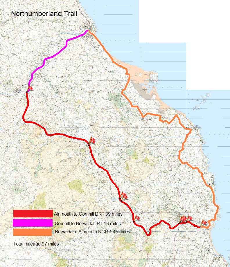
Borderline Greenway's envisioned Northumberland Trail loop
Like what you've read? To receive New Civil Engineer's daily and weekly newsletters click here.
Have your say
or a new account to join the discussion.